Tag Archives: climate

Yet another iteration…

Aerial


Trying to work out the best way to show a view of the whole project. I think this is working better than the Axo I posted earlier. The Resource Conservation Operations Centre occupies the northern end of the large parking lot, the dry pond is below the building and parking surface and both pedestrian greenways are visible intersecting at the entry plaza to the east of the RCOC. The recycling drop off centre is sheltered by a light canopy – the edge of the canopy frame would support a cable fence to black-bear proof the facility.

Tagged , , , , , , , , , , , , , , , , , , , , , ,

Content to graphics…

The images I posted earlier today represen the kind of raw output images that Revit gives me access to once I’ve built the model with sufficient detail. One drawing I have on my list is a conceptual drawing that speaks to the landscape reference and integration in the geometry of the roof and the design approach in general. Similarly the cyclical water levels of clear lake represented in the graph from Parsons and McGuinn in Prairie Perspectives Vol 2 is an idea that is present in the use of a sine curve to drive the geometry of the roof structure. The three canopy roof structures expand on the idea of surface – impermeable surfaces being the primary source of accelerated stormwater runoff due to human inhabitation. The other diagrams speak to a strategy to use the proposed RCOC and stormwater retention pond as a ground-coupled heating strategy for the new building and to offload expensive environmental control costs from nearby heritage buildings. The green diagram shows how the stormwater system and RCOC work together with the existing Visitor Centre and Ominik Marshwalk to extend the Park’s most popular trail and to highlight the town’s sustainably stormwater management infrastructure and the research being done at the RCOC.Sine Curves - Base Image

Tagged , , , , , , , , , , , , , , , , , , , , , , , , , , ,

Validation

One of the main systems level ideas I have been working with is that instead of using a currently forested region of the Wasagaming town site as a dry pond, Parks Canada could use the existing parking lots as natural filter points that slow flows, cleanse water and build resilience into the system. The map below shows the simplistic sketch of my proposal – a pedestrian boulevard and green swale to carry stormwater to the large underused parking lot in the middle of town. The parking lot acts as the reservoir/dry pond and another green swale takes the flow through from the dry pond to the Ominik Marsh system.

Screen Shot 2013-02-21 at 1.27.06 PM

This strategy just seemed natural to me – it made sense from the study of topography and of the urban systems and ecosystems. Then I found this post card for sale on ebay!

Screen Shot 2013-02-21 at 1.18.54 PM

If you can locate yourself using the above map, the large parking lot I am proposing as a reservoir is actually wetland in this image! This low point was obviously part of the collection and flow through of surface water moving through Ominik into Clear Lake. The placement of my reservoir is really a step BACK towards the pre-urban condition but it a way that both addresses the natural system needs and human use of the site. Very exciting to have my reading of the landscape validated by these kinds of finds. Why put a man-made marsh where a forest wants to be? Why put an impermeable parking lot where a marsh wants to be? My solution is to put a marsh AND a parking lot where the town and the topography and the ecosystem suggest they should be and by studying the system in layers and finding ways to tease apart these layers I hope to achieve integration of infrastructure and landscape – and within that, building and landscape as this parking lot is also the site of my building proposal.


Tagged , , , , , , , , , , , , , , , , , , ,

2013

Well it’s been a few weeks since I updated here and I took a nice hiatus from thesis work to enjoy some family time and some long overdue laziness.  Now that I have caught up on the cinematic releases of the latter half of 2012 I think I am ready to dig seriously into the final leg of my thesis.  This has been helped along by my acceptance to the Parks and Protected Areas Research Forum of Manitoba (PPARFM) conference in Winnipeg this January.  I will be presenting my research in progress in poster format to the conference attendees – ecologists, biologists, resource managers, tourism operators, planners, etc.

This is really an exciting chance to present architectural design research in an interdisciplinary forum and one that is not always possible.  I am thankful for the encouragement from Sean Frey – my contact at RMNP – to apply for this conference and I am looking forward to seeing what comes of it.  For now I’ll post my abstract as it was submitted for the call for papers:

Architectural framing of sustainable civic infrastructure: Defining regional identity in a National Park town site.


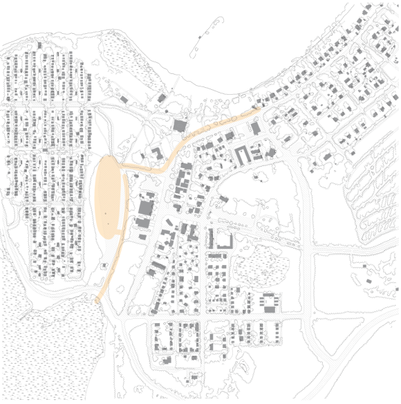
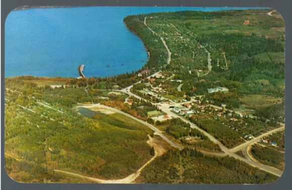
Based on critical analysis of the existing natural and urban systems in Wasagaming, Riding Mountain National Park, Manitoba, a distributed stormwater system that is architecturally integrated into the existing urban fabric is proposed.  The architecture delineates public space and builds upon existing park programming year-round from walking paths and parking to picnics, hikes and seasonal sports. These proposals are located where water is collected, filtered and returned to the aquifer creating visible destinations out of the infrastructure to grow relevant visitor experiences through robust, innovative, and sustainable infrastructure.

Parks Canada has taken major steps to upgrade dated water infrastructure in the town of Wasagaming. The drinking water system and wastewater and sewage system have both been completed while the stormwater upgrade is designed and shovel-ready. A review of the proposal reveals that the system will continue to overflow during peak loading, maintaining problematic system relationships. This approach lacks sustainability and forethought and fails to contribute actively to the unique identity of this Manitoba parkland.

Without investment in civic or regional identity, the opportunity is lost to use these projects to develop the seasonal tourism economy or support local stakeholders. Precedents like the Sherbourne Common in Toronto or the Shepard Environmental Education Centre in Calagary demonstrate how an investment in sustainable infrastructure driven by architectural design can create opportunities for tourism, gathering, and community building with an explicit connection to the natural systems upon which we depend. Through architectural design these projects achieve social sustainability in addition to goals of environmental and ecological sustainability.

Tagged , , , , , , , , , , , , , , , ,

Building as System

I started trying to understand the broader systems context of my thesis topic by make a model that showed up a while ago in this post.  This was a critical transition to working in a more inductive way – trying to find a solution in my understanding of the problem.  It was at that point that the scope of the project changed from a building that accepted the infrastructure as built and proposed to one that sought to rethink the issue of stormwater as a whole and to find opportunities for architecture within this critical analysis.

In an attempt to move the project forward I have built a second systems model at twice the scale (1-5000) of the last one that explodes the stormwater layer from the last model into its constituent parts and includes the vegetation/permeable layer and evapotranspiration connectivity of flow.

The third model I plan on making is only in digital form but I will laser cut and assemble it tonight.  This one makes a huge leap from 1-5000 to 1-50 scale.  The language is the same, but this model shows the architectural or building scale proposals I am working on and bring the ideas of structure, programme, identity, permeability, infrastructure, systems analysis and diagramming together to represent abstractedly one of the groundwater recharge zones I am proposing with a water tower and a permeable paving system.  Pics of the finished model to come!

Tagged , , , , , , , , , , , , , , , , , , , , , , , , , , , , ,

Re-iterating iterations…

I’ve been listening to this track a bunch while working the past few days.

I did say this was an iterative process somewhere back there.  This map has really come a long way and I think it is now really helping to contextualize my project in a way that it wasn’t able to in it’s previous forms – first here and then here.

Tagged , , , , , , , , , , , , , , , , , , , , , , , , , ,

Systems model

This is just a quick update of the last post I made about modelling systems and flow as a way of working out where and how an infrastructural and architectural project can affect the existing situation.  The blue layer is three major storm water catchment areas for Wasagaming, pink is the drinking water system, yellow the wastewater and sewage, blue is the ominik marsh waterway (which connects back to the octopus lake system not included in the model), the green layer is the marsh/bog around the waterway in ominik which is responsible for a lot of groundwater recharge, the brown is south lake – the last filter between the marsh system and clear lake.  Clear lake is shown in beige, the slate blue base is the groundwater aquifer and the transparent clouds are…well clouds.  The acrylic arrows show connectivity and flow direction and the whole model stands up because of the interdependence of the systems.  Gravity is really the litmus test for connectivity here – if these systems weren’t truly interdependent then the whole thing would (literally) come crashing down.  What I am realizing is that the weakness in the Stantec proposal for storm water infrastructure is that it rerouted a huge amount of flow through these other systems rather than addressing the “natural” path stormwater should take – from catchment area directly to groundwater.  Stay tuned for more!

Tagged , , , , , , , , , , , , , , , , , , , , , , , , , , , ,

Systems Integration

One of the realizations I have made in trying to work my way past this recent block is that one does not simply design a system and THEN integrate it… I’ll resist the urge to make an incredibly nerdy iteration of the Boromir meme – click here if you don’t know what I’m talking about.

So the work I have done so far has developed a proposal that has more to do with itself than it does the infrastructure I am studying – this is a problem.  The solution?  Really understanding the systems that are in play and allowing the analysis of said systems to be a generative force in the design.  To this end I’ve done something I should’ve done a while ago and will complete the digital model here before heading down to the laser to cut a physical version.


Upward and downward flows are coloured to indicate their source.  The waste water, storm water, drinking water and natural waterways are all modelled showing their connection to the aquifer (the model base) and the atmosphere (cloud shaped surface at top of model).  Already I am more excited about this piece than anything I have done in the past week.  I think this has the potential to go somewhere.  Below is the base aerial photo that most of the linework was taken from.

Tagged , , , , , , , , , , , , , , , , , , , , , ,

across scales.

Building on my last post I have been working on a more region specific map that talks about proximities, context, watersheds and water bodies, topography, borders, transportation and urban centres.  This is the second in what I anticipate will be a series spiralling ever closer in to the scale of my specific thesis site.  This way of working enables me to sort through the data I have collected and examine it at appropriate scales.  In these exercises I am examining first principles of site, context and potential.  More to come, click to enlarge.

http://www.naryn-davar.ca

Tagged , , , , , , , , , , , , , , , , , , , , , , , , ,